
Introduction
Earlier this year I visited Gathaagudu (Shark Bay) for an aerial photography workshop with Australian legends Tony Hewitt and Peter Eastway. They have distinguished themselves both nationally and internationally for their landscape and aerial imagery, winning many accolades in the process, so I am excited to have the privilege of spending time with them. It’s been a few months since I returned, so this article is a reflection of my time suspended over Gathaagudu Country and includes some tips about aerial photography.
I arrive at Denham airport a little flustered but excited. My flight out of Sydney had been delayed and I make my connecting flight to Denham with 15 minutes to spare. Both Tony and Peter are waiting to greet me as I disembark. Everything is quite laid back in Western Australia and I am already beginning to feel relaxed and glad to be out of wintry Sydney for the week.
Shark Bay is located in the Indian Ocean at the most westerly edge of the Australian continent. It has some exceptional natural features which has earned it UNESCO World Heritage status. Contributing to this status are some of the world’s largest and richest sea-grass beds, an amazing dugong population and colonies of stromatolites, considered to be the oldest forms of life on earth. Five species of endangered mammals call this place home and most people who have visited Monkey Mia would have encountered the loveable bottlenose dolphins who visit every morning.
I had visited Shark Bay about 2 decades ago, but this will be my first aerial experience. Words don’t do this place justice so I hope my images might. We will spend the next few days making imagery while suspended over this landscape from a Cessna, with the doors open. I can’t wait.
Planning and Gear
If I were coming here on my own, I might have been pouring over Google Earth to scout out the locations I wanted to fly over so I could instruct the pilot. However, Tony and Peter have been here many times before so I can relax and let them plot our flight paths. The pilots are also experienced in flying photographers over the area. I had chatted to Tony about what gear to bring before I got here. The 7kg limit on carryon baggage means that some of my lenses have been left behind.
Some professional aerial photographers prefer prime lenses but for this shoot I have decided to rely on a mid-range zoom, the Canon RF 24-105mm lens and my Canon R6 body. If I had a 70-200mm lens, I would have brought that along but it’s good to remember that the aircraft can also act as a zoom with a little co-operation from the pilot! I have my Canon 6D as a backup with my 100mm prime lens, but I didn’t need it. I chose to leave my filters and polarizers behind to ensure maximum light transmission, but a polarizer could be useful for those oblique shots when shooting a bright sky or to cut down the reflections off a dazzling water surface.
Warm clothing and some travel calm pills also came in handy. You will need some backup batteries and memory cards, an external hard drive for storage and a laptop to download and check your images between flights.
I had chosen to not study the many images that had been taken here previously although if you are on social media in Australia, you can’t really avoid seeing images of Shark Bay. You might find it useful to study the images of this area as part of your planning. One of the highlights of our trip would be visiting the information center in Denham and seeing the gallery of images that the ‘Ninety Degrees Five’ collective (ND5) shot in this area about 10-years ago. Besides Tony and Peter, the group includes Michael & Christian Fletcher and Les Walkling. This exhibition of aerial photography shows us there are other ways of mapping reality than those that dominate our everyday lives. If you are in the area, make sure to spend some time in this gallery.
Understanding the Challenges and Settings for Your Camera
There’s time to freshen up on our first evening before we sit down as a group to chat about settings over a few glasses of wine, crackers and cheese. I set up my camera as we chat and save the settings as a custom function (C.Fn) so I can easily recall them when I am up in the air.
Movement and weather conditions will be one of the many challenges we will contend with. The wind factor can make your plane ride even bumpier than usual so choosing the right shutter speed is paramount. While you may wish to choose shutter priority, I decided to shoot on manual and fix my shutter speed at 1/2000 sec. Peter explains that we won’t need to worry about depth of field, given how far away we will be. The landscape is also mostly flat. I shot at an aperture of f/4 -f/5.6 and I rarely had an image that was blurry. I chose an expanded auto focus area given we were in constant movement. I also used my back button focus to pre-focus each time I took a shot, as I was constantly changing my focal length and composition.
Because I didn’t want to introduce too much noise, I set my ISO on Auto, but restrict it to a range between 100 and 3200. We are fortunate that the light was mostly bright while we were shooting. However, if you find your ISO is getting too high and conditions allow, then adjusting your shutter speed might be an option. My metering was set at evaluative so the camera would average exposure for the entire scene. I also turned on the stabilization of my lens. I choose single shot frame advance as there isn’t a need to spray and pray in aerial photography!
Up & Away and Shooting
The good thing about aerial photography is that you don’t really need to wake up too early, but we postponed breakfast till we had completed our flights. Tony has brought us some ginger chews and I remember to swallow my travel calm before we leave for the airport. I don’t really get air sick, and this time was no different. I take a spare battery and memory card and slip them into my jacket pocket. Shooting with two memory cards is also an option if your camera allows.
Tony is flying with me on our first flight. We are flying with Shark Bay Aviation and our pilot Scott helps me on with my harness. It will be really noisy once we are in the plane, but we have a communication system that will enable us to chat. Sometimes simple sign language gestures like a thumbs up can also be useful. Tony reminds me to take some images as we takeoff and check they are sharp. I also keep an eye on my histogram. My images are looking good.
The previous day we had chatted about the types of images we might take. If you want to shoot looking straight down, then you’ll have to instruct the pilot to put the wing down. You can also shoot oblique images that might include the horizon. These are not your typical abstract aerials, but they can be quite unique because of that. We had been instructed to not lean out of the window or door to avoid becoming part of the slip stream. Because we are harnessed, we are definitely very safe!
My zoom lens helps me avoid the struts and wheels of the plane in my composition but that’s not always possible. I remember that I can always clone out unwanted bits, so I don’t let it limit my composition.
Finding Metaphor and Meaning in Composition
I have always been fascinated by the ancient aerial paintings of Aboriginal artists. They imagined themselves hovering over Country as they documented the natural and mystical forms they visualized. Knowing their country intimately was crucial to their survival. Indigenous art is on my mind while I am in suspended in the air.
While colors, textures, form and shapes are central to abstract photography, many photographers are keen to also to find meaning and metaphors in their images. As this is the first time I am seeing this landscape I am hopeful that I can find meaning and metaphor later. I concentrate on looking for patterns. Highlights over water can blow your exposure so it is always better to underexpose by at least a third of a stop.
The Flights
It’s hard to beat the intensity of colors in an Australian Landscape. The red earth, the teal blue ocean, the white sandy beaches, and the variety of greens in both the water and landscape make for a beautiful color palette. Our first flight is over Francois Peron National Park where the outback reds meet the ocean blues. Tony’s image of Little Lagoon is well known now but I was still keen to put my own spin on it. I think that first flight took my breath away. I can’t stop smiling when we disembark. I think it would be fair to say this is one of the most stunning places in the world and seeing it from the air is perhaps the only way to truly appreciate its expanse and beauty.
Our second flight concentrated on the area known as Useless Loop. It’s hard to believe but even in this remote part of the world, humans have left their mark. Useless Loop isn’t really open to the public although you can get close with a 4wheel drive. The best way to see this salt mine that produces the purest salt in the world is from the air. The area was wrongly named by Frenchman Freycinet when he visited in 1801 because he thought there was a sandbar blocking access. The captivating patchwork of shapes and colors found in the salt ponds provide amazing opportunities for geometric compositions.
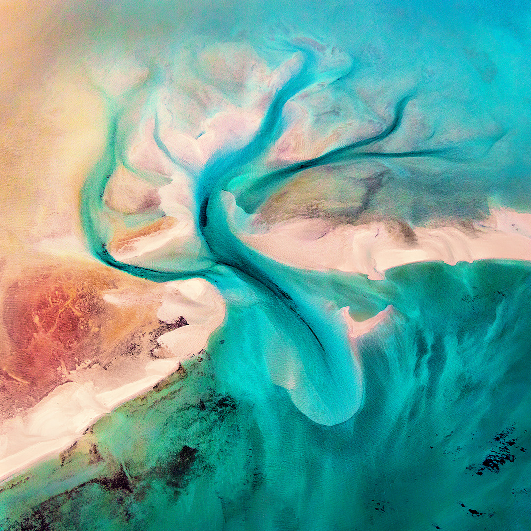
Our third flight is during the late afternoon and is mostly over water and sand dunes. As I look down on our beautiful planet from the safety of a Cessna—albeit with the doors open—I am naturally drawn to the pathways and patterns carved by water systems. I have never seen so many incredible shapes and patterns in the ocean or on a beach and I am mesmerized by them.
As the sun begins to set, the beautiful glow of the afternoon sun lights up the landscape. The light highlights the biridas on the ground which appears to be an otherworldly landscape. They were landlocked saline lakes between sand dunes when sea levels were much higher than they are today. The drop in sea levels caused the lakes to dry and left these salty hollows that we call biridas.
As we fly over this landscape for the last time, I reflect that this area was home to the Malgana, Nanda and Yingkarta people. I wonder what life was like for them as I look down on this landscape in awe. We fly over Useless Loop one more time and then discover some amazing sand dunes and the rugged Zuytdorp Cliffs. I am excited when I spot egg island— a beautiful island on the East side of Dirk Hartog Island. The island was beautifully captured by Peter Eastway and his image had caught my attention when we viewed the exhibition of the ND5.
Reflection
All too soon it was our last dinner together. We had engaged in some wonderful conversations about art and photography and aerial imagery. We had discussed processing, looked at one of Tony’s photography books as well as their print exhibition which had sparked a trend not just in aerial photography but also in bringing photographers to the area.
I will always treasure my memories of this trip with gratitude and remember this week as one that inspired another step in my creative journey.